How Satellite Imagery Reveals Future Fishing Hotspots

The brunt of summer is here, and the Southeast is experiencing major heat warnings, with heat indexes cresting past the 100-degree mark for multiple days in a row. Even night fishing is like being in a sweat lodge. Now is the perfect time to take a couple of days away from the sweltering lake and stay in the AC to manage tackle, oil reels, tie FGs, and watch archived tournament footage.
This is also a great time to stay in and scroll around on the Deep Dive app to check out how this summer’s scorching conditions could create hot fishing opportunities this winter and spring. Such warm water accelerates vegetation growth in lakes, and it’s reaching its peak growth right now. If you fish vegetation lakes, or have some on the tournament schedule next year, now is the time to use the Deep Dive app to see if submergent vegetation is creeping into new areas, making them more productive.
E-Scouting with Recent Satellite
The Recent Satellite feature was added to Deep Dive’s suite of real-time tools back in March of 2026. So, this is Recent Satellite's first summer in action. Given the long, bright days of July and August, the Recent Satellite feature has captured some up-to-date images of this summer’s vegetation growth in lakes across the country.
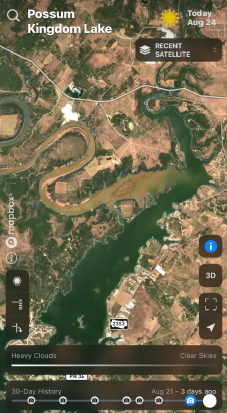
Florida lakes provide good examples of seeing where the vegetation is growing in the summer of 2026 – and where it’s not. These images reveal the hard edges of vegetation, as well as the gaps and holes in flats, giving away locations of subtle ditches and depressions. It shows where new grass is forming points and topping out in new places, which could become new springtime hotspots. Just as importantly, the images also show where grass is mysteriously disappearing, perhaps due to weed control activity – places you may want to avoid in the spring.
Low Water, High Potential
The usual Florida fisheries suspects like the Kissimmee Chain, Harris Chain, St John’s River, Lake George, Rodman, Orange, and, of course, Okeechobee are all worth peeping at. Speaking of the Big O, conditions in Florida over the last year have dropped the water levels some 7 feet, to about 3 or 4 feet below normal. This has helped fuel a flush of new vegetation growth in the shallows and should put the legendary fishery back on track for another up cycle – as long as no tropical systems rain on its parade. Tracking the vegetation’s progress on Recent Satellite will be something to monitor heading into September and October.
Other popular vegetation lakes across the Southeast that are worth checking out on Recent Satellite include:
- Santee Cooper (Marion and Moultrie)
- Wheeler Lake
- Lake Guntersville
- Lake Seminole
- Ross Barnett Reservoir
Another particularly interesting lake to study right now is the notorious tournament destination Sam Rayburn in Texas. The water is about 7 feet low, revealing drains, bars, humps, and points. Even more intriguing is the amount of new green growth springing up around the dry bank. Given a couple more months of low water and hot weather to fuel more bank growth, Rayburn could become a whole “new” lake with some spring rains in 2027.
Fertility Seams and Water Color Changes
Although not as prominent, another phenomenon that can be seen in the Recent Satellite images during summer is fertility seams in large reservoirs, especially along the TVA chain of lakes. These seams and eddies are where shad gather and feed on phytoplankton. Close inspection of subtle water color changes along the main river channel reveals where the main river current flow meets slightly more colored water, due to higher fertility, or stagnant pockets of water along flats and bluffs. These color differences may not be as visible on the water, but are more identifiable in satellite imagery, providing a better idea of where daily current draws rub up against the still water.
Recent Satellite images are not always perfect. There is cloud clutter to contend with, and the resolution can vary. Over the last 30 days, most lakes have had about 10 to 15 updated images posted. Of those, two or three images will capture the lake on a sunny, clear day to reveal summertime grass growth, fertility seams, and water color changes that can be gold mines later this fall and into the winter and spring.
If you’re looking for an excuse to dodge the heat and explore summertime changes on other lakes while enjoying some AC, Deep Dive’s Recent Satellite function has the remedy for you.