Using water color to find warmer water

It’s the end of January, and water temperatures across the country are bottoming out for the year. From now through April, daylight hours will increase, and inevitably, water temperatures have nowhere to go but up.
Warming water is at a premium during this time of year. Finding specific zones where the water temperature is rising a few degrees warmer than surrounding areas can be the difference between a crush fest and another anemic day on the lake. However, what if you are trying to find warmer water on a lake that is 30,000 acres, 50,000 acres, or even 100,000 acres? Suddenly, the task of finding warmer water becomes monumental.
Finding Warm Water for Spring Bass Fishing
An old-school way to find warmer water is to look in creeks, bays, pockets, and coves on the northern and north-eastern sides of a large lake. The premise is that the north-eastern areas are more protected from cold north winds and receive the afternoon sun for longer periods of time.
Over the years, professional bass anglers have developed additional techniques to locate warmer water quickly. In some lakes, there is a unique correlation between water color and water temperature. Subsequently, there will be a water color that signals warmer water. Once that particular water color is identified, it can usually be replicated across the lake. The exact water color, however, varies and changes with each lake and the conditions.
The key “color” is usually described as having a perfect tint, tinge, or stain. It is not gin clear, but it’s not fresh mud either. It’s water that has picked up color, either from a rain or wind event. At one point, it might have even been muddy. But now it’s had a couple of days to stabilize and absorb radiant heat from the sunshine. A quick check of the water temperature gauge will verify this potent water color. Even a degree or two increase in water temperature can be a bass magnet. Once this water color is identified, it can be used as a color index to find more of it across a 50,000-acre lake.
Pro Insights: Chris Zaldain on Water Color
Professional Angler Chris Zaldain has been fishing the Bassmaster Elite Series for 15 years. During that time, he has seen every trick there is to finding warmer water in a massive fishery.
“Back in the day, some veteran pros would even charter private plane rides to fly over tournament lakes during practice,” Zaldain recalls. “That’s not allowed anymore, but that just shows you how much value a bird’s eye view is for evaluating water quickly and finding more stable and perhaps warmer water.”
“Other pros would commit the first day of practice in springtime events to running a hot lap around an enormous lake,” he recalls. “Running 75 miles around a lake just to check water colors and temperatures was not out of the question. And even when you found the right water color to look for, you still had to ride the lake burning gas and time looking for more of it.”
Using Water Clarity Maps to Save Time
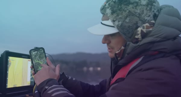
These days, Zaldain has found a much better way to assess a lake’s water color.
“Thanks to the Deep Dive app’s Water Clarity maps, I can get a bird’s eye view of water color right on my phone,” he says. “Deep Dive depicts water colors with different shades of coloring. And even though it doesn’t show water temperatures directly, if I find the particular shade of color that holds better water temperature, I can then use the Water Clarity map to find more of that same color without riding the entire lake.”
For lakes featuring Water Clarity maps, Deep Dive attempts to refresh the maps on a daily basis. However, if cloud cover interferes with the updating process, even a Water Clarity map that is a couple of days old provides significant information as to how water color migrates through a lake.
“The Water Clarity maps tell the story of how the stain lines move,” he explains. “It shows which arms, creeks, and bays have more color compared to the others. Just seeing these water color contrasts across a lake is a powerful tool we’ve never had before.”
Tracking Stain Lines After a Cold Front
After using the Water Clarity maps across multiple lakes in the spring, Zaldain has learned that its effectiveness excels after a cold front has passed through. The rain associated with the front usually causes a push of muddy water from the primary tributaries. Radiant post-frontal sunshine begins to warm the muddy water. After a day or two, that slug of muddy water begins to move down the lake and settles out.
“This is when the Water Clarity map will really begin to show different zones of water color,” Zaldain explains. “Sometimes the colors will look like large bubbles of contrasting shades. Once you figure out what shade is the warmest, you can then use the map to match that shade of color in other areas to continue to find warmer water.”
The Water Clarity map even has a filter function that allows a user to pick the preferred shade of color they are interested in finding and then shows where only that particular water color is located.
Spring is just around the corner. Instead of wasting a hot lap around an entire lake, let Deep Dive’s Water Clarity app help lead you to warmer waters.