Location Over Lure: Why Finding the Right Spot is Everything in Bass Fishing

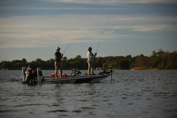
Every angler has heard it: "Location, location, location." It's a mantra in bass fishing for a simple reason – it's the absolute truth. You can have the hottest new lure in the perfect color, tied onto the best rod and reel combo, but if you're casting into empty water, you're just practicing your casting. Bass aren't evenly distributed; they congregate in specific areas based on conditions, structure, cover, and food availability. Finding these "right locations" is the single most crucial factor in consistently catching fish.
The challenge? Lakes and rivers are vast and complex. Identifying those high-percentage spots can feel like searching for a needle in a haystack, often involving burning expensive gas and precious fishing time just driving around, hoping to stumble upon active fish.
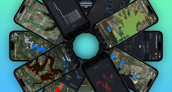
This is where technology, specifically the Deep Dive app, changes the game. Deep Dive is built on the premise that visualizing critical, often unseen, data is key to unlocking the location puzzle. It moves beyond basic mapping and weather, providing advanced insights that help guide you to where the bass should be.
If location is king, how does Deep Dive help you find the throne?
1. Learning from the Pros: Tournament Patterns
Imagine knowing where professional anglers caught their fish on lakes similar to yours, under conditions mirroring the ones you're facing right now. Deep Dive's Tournament Patterns feature does just that. We analyze countless hours of pro tournament footage, meticulously logging catches by lake section (upper/mid/lower, main lake, creeks, backwaters), structure, cover, bait, conditions, and more. When you select your lake and fishing conditions (like season and current weather), Deep Dive filters this massive database and projects the relevant catches onto your map. You instantly see which sections of the lake have historically produced under similar circumstances, giving you a powerful starting point and insight into the patterns working there.
2. Seeing the Unseen: Water Clarity Maps
Water clarity is a massive factor in bass location and behavior. Is the water clear, stained, or muddy? Finding out usually requires lots of looking around. Deep Dive uses daily satellite imagery to generate detailed water clarity maps. You can see the estimated clarity across the entire lake before you even launch, identifying promising transition zones or areas with the specific clarity you want to target. Need to see how things have changed? You can review clarity maps from the past 30 days. This feature alone is a huge time-saver, eliminating guesswork and letting you focus your efforts efficiently.
3. Uncovering Hidden Gems: Water Inflows
Current brings nutrients, oxygen, and baitfish – and bass know it. While major river arms are obvious, many lakes have smaller, less apparent creeks and streams feeding into them. Deep Dive utilizes the USGS National Hydrography Dataset to map all these inflows, color-coding them by average annual flow volume. This reveals potentially overlooked hotspots where moving water enters the main body, creating feeding opportunities that other anglers might miss.
4. Harnessing the Breeze: Wind Effects
Wind is one of the most dynamic forces affecting bass location daily. It pushes plankton, which attracts baitfish, which attracts bass. It also creates currents and dictates which banks are getting hit with wave action – prime ambush territory. Deep Dive's unique Wind Effects layer visualizes this dynamically. It calculates wind fetch, speed, and direction to show you:
- Wave Size: Color-coded icons (green for calm, red for large waves) across the lake help you understand conditions and potential feeding activity (or find safe areas).
- Bank Impact: Crucially, it shows exactly where waves are hitting the shoreline and at what angle. Targeting these wind-blown banks, points, and cuts is a classic pattern, and Deep Dive shows you precisely where it's happening now.
5. Following the Flow: StreamFlow Visualization
Especially crucial for river systems and reservoirs with significant tributaries, understanding water flow is key. Deep Dive integrates NOAA's National Water Model to map stream and river flows across the US. You can see 2 days of history and a 7-day forecast, visualized directly on the map. Scroll through time to see how inflows are changing, identify areas with increased or decreased current, and anticipate how bass will reposition in response to changing conditions. Tap any stream for a detailed flow graph. Seeing all the contributing flows simultaneously provides an unparalleled understanding of the lake's dynamics.
6. Reading the Levels: Lake Level & Discharge (Current Flow)
While the map layers show where spatially, understanding water level fluctuations and dam discharge (outflow) tells you how fish might be repositioning vertically or relating to current. Is the water rising, pushing fish shallower into newly flooded cover? Is it falling, pulling them out to primary points or channel edges? Is increased discharge activating fish near the dam? Deep Dive provides the last week of available data for hundreds of lakes, helping you interpret how recent changes might be influencing fish location relative to structure and cover.
Location First, Then the Lure
Notice a theme? All these features are about understanding the environment to pinpoint where the bass are likely to be. Once you've used Deep Dive's mapping and data tools to identify high-percentage areas – maybe a wind-blown point with stained water near a creek inflow that Tournament Patterns highlights – then it's time to think about the lure.
Stop Guessing, Start Finding
Bass fishing success hinges on being in the right place at the right time. While lure choice is important, it's secondary to location. Deep Dive empowers you to drastically reduce unproductive searching time by leveraging advanced data visualization. By understanding water clarity, inflows, wind impacts, historical patterns, and water level trends, you can make highly educated decisions about where to fish before you even make your first cast. Use Deep Dive to focus on the location, and you'll find yourself spending a lot more time fighting fish.