How to Find and Fish Thermoclines for Summer Bass

The scientific community has recognized the temperature stratification of water and the formation of thermoclines in lakes since the late 1800s. What has been a mystery up until the last few decades, however, is how bass relate to thermoclines. Given the current era of high-powered electronics, many of those mysteries have now come to light.
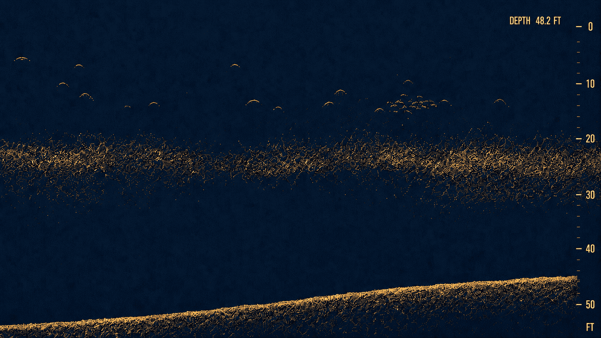
August is the month when the word “thermocline” gets used most often in bass fishing. As the water heats up all summer, it begins to stratify into layers: Warm water piles up on top from solar heating, and the coldest water gets pushed to the bottom. Eventually, there is a definitive boundary between the two layers, which is the thermocline itself.
Understanding Water Layers and Depth Variations
A thermocline usually forms anywhere from 10 to 50 feet, and its thickness can vary from 2 to 10 feet. In general, the more stained the water, the shallower and thinner the thermocline will be. And the clearer the water, the deeper and thicker the thermocline will be. The average thermocline hangs out in 20 to 30 feet and will have a temperature drop of 10 to 20 degrees from above it to below it.
The thermocline is intriguing because above it is warm, oxygen-rich water where fish of all types prefer to be. Below it is cold, sterile water where nothing wants to live. Between the two, a thin wedge of water traps a layer of nutrients hosting all types of phytoplankton and zooplankton, which is the actual thermocline. And this is where a lot of shad and fish activity happens in the summertime.
The History of Thermoclines in Bass Fishing
In the 70s and 80s, the thermocline was a big deal in bass fishing; it had a perceived broad influence over bass behavior across the nation. Anglers believed it was the magic carpet that all bass rode on in the heat of summer. There were meters and probes made to drop down through the water column to find the thermocline.
In time, sonar became sensitive enough to “see” the thermocline. Eventually, the thermocline craze faded. Mostly because thermoclines only set up hard in deep impoundments with very little water flow for a short period of time. So, its influence only really impacted a distinct type of lake for a small portion of the year. That’s not to say the thermocline is irrelevant. For those lakes that do have distinct thermoclines, it certainly does impact fish location and behavior.
Ideal Conditions and Key Target Waters
The primary ingredients needed to produce thermoclines include hot weather, long periods of solar penetration, 85-degree-plus water temperatures, water depths of 15 feet plus, stagnant water, and very little wind or rainfall.
Clear, deep highland impoundments located in the South, West, and Midwest are prone to solid thermoclines. Florida lakes, or shallow natural lakes, rivers, and river-run impoundments are more immune to thermoclines due to shallower depth or plenty of water flow.
Lakes like Mead, Table Rock, Ozarks, Bull Shoals, Lanier, Hartwell, Martin, and even Texas lakes like Toledo Bend, Rayburn, and Travis are all candidates for solid thermoclines.
Big TVA power-generating lakes like Guntersville, Wheeler, Pickwick, and Chickamauga don’t have as much of a thermocline due to the tremendous current flow from power generation. However, in periods of low flow and in deeper areas of no flow, thermoclines can form.
Lakes that are tricky about thermoclines include impoundments such as Lake Eufaula (Alabama), Watts Bar, and Lay Lake. These are river-run lakes with deep main-lake basins, bays, and low-flow creeks. If these lakes are running consistent current, it can keep a thermocline broken up. But if the current slows, or generation periods become short, or stagnation occurs, thermoclines can form quickly, especially in the deeper low-flow bays and creeks.
Thermoclines need to be fed with sunlight and stagnation to be maintained. Increased current, several days of rain, heavy cloud cover, and even heavy wind can break thermoclines up in a hurry.
Expert Insights: Spotting and Fishing the Line
Professional Angler Caz Anderson from Haysville, North Carolina is very familiar with thermoclines in the heat of summer. As a guide on some of the deep, clear impoundments in the mountains of North Carolina, he deals with thermoclines all summer long and has some simple rules to keep things from getting too complicated.
“If a thermocline exists, it can be found with most modern-day electronics, whether it’s with 2D, downscan or forward-facing sonar,” he says. “Simply turn up the sensitivity or the gain until you see a hazy line appear in the middle of the water column. There will usually be fish of all types either in the thermocline or just above it that help define it. But if there is a thermocline, you will see it.”
“On Lake Chatuge, it sets up at about 35 feet,” he continues. “Some days it’s very solid and consistent, and other days it’s patchy – kind of here and there – depending on weather and current flow. Usually there is no thermocline near the dam, due to the water being pulled from the dam area.
“If I can find a solid thermocline, that’s where I prefer to fish because it essentially helps eliminate water by forcing most fish up into the upper half of the water column.”
Anderson’s Thermocline Tactics
- Rule #1: Always Fish Above the Line: Focus efforts strictly from the thermocline up to the surface. Anderson avoids fishing below it because there is very little fish life in that cold, oxygen-depleted zone.
- Adjust Screen Ranges: “Even if I’m fishing over 60 or 70 feet of water, once I know the thermocline is at 35 feet, or 30 feet or 25 feet, I’ll go ahead and set the bottom range of my scope to the depth of the thermocline, that’s where all the activity is.”
- Target Intersecting Structure & Cover: “A long point or hump that comes up and pierces the thermocline is good,” he continues. “It’s even better if there is cover like a rock pile, brush pile, stump or timber mixed in – any hard cover that mingles with the thermocline provides a place for bass to ambush forage that is using the thermocline.”
In the mornings, Anderson will fish up shallower on points and shaded banks with topwaters and subsurface lures. Later in the day, he moves out to areas where the thermocline meets structure and probes them with jighead minnows, jigs, drop shots, and shaky heads.
The formation, location, and density of a thermocline are all at the mercy of water color, weather, current, and direct sunlight penetration. Thankfully, today’s advanced electronics can quickly locate thermoclines and pinpoint the fish using them, eliminating much of the mystery surrounding this unique layer of water.